Special Technologies
  GPS Equipment
Professional GPS Survey Systems
GeoPositioning Satellite (aka Global Positioning System, GPS) equipment provides accurate position by latitude and longitude using radio signals from a system of 24 orbiting NAVSTAR satellites.  Position is determined from the relative positions of any three (or more) of the satellites to the GPS receiver.  At all times a minimum of four of the satellites are visible anywhere on the planet at the same time.  Some systems also utilize the GLONASS satellite system.
Mobile Mapper
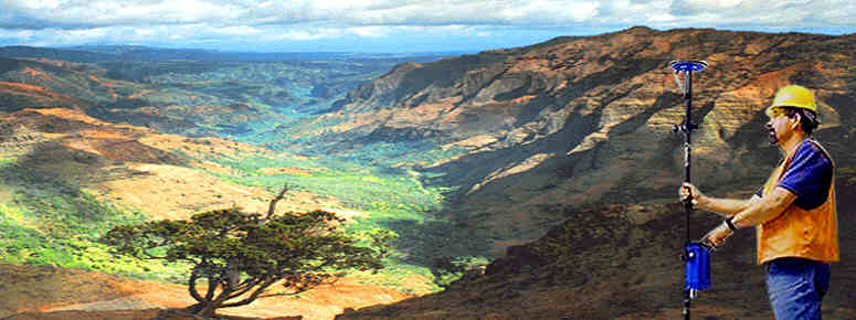
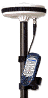
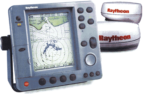
Types of GPS Equipment range from lightweight handheld models for personal use outdoors, to high resolution systems designed for professional survey crews in conjunction with advanced office based CAD / mapping software. 

Accuracy is dependent upon the equipment being used.  Most basic equipment is accurate to 25 meters.  Equipment utilizing GPS Differential Beacon Signal (DGPS) receivers deliver positions accurate to within 10 meters, and potentially to 1 meter.  The Wide Area Augmentation System (WAAS) and European Geostationary Navigation Overlay Service (EGNOS) satellites can provide further GPS signal correction to compatible equipment. Only the most expensive professional survey equipment and military systems can achieve centimeter accuracy.
RL70RC Integrated GPS Cartographic System
Very substantial applications of GPS technology have been made for marine navigation, and in-vehicle land navigation.  These navigation units range from basic alpha/numeric display units, to advanced cartographic display systems utilizing electronic charts available from several sources.   The most advanced marine systems provide color charts for anywhere in the world, with active ship's RADAR and GPS position integrated into the display.  The least expensive cartographic units are handheld and portable.  The most sophisticated and most accurate, are fixed, mounted units with exterior antennae, DGPS receivers, and connections to other onboard electronic systems.

Certain additional features are available depending upon manufacturer and model.  Generally, the more features included and the more accurate the position reported, the more expensive the equipment.  A wide variety of GPS equipment is manufactured by several companies.  The equipment referenced below is only an example of models and types of units which can be provided.  Contact us for information on equipment best suited to your needs and budget.

ORDER Globe Golf Balls
Globe Golf Balls
3 to a carton 
us$19.95

For anything related to GeoPositioning Satellite systems, GPS equipment, Geographic Information Systems, or 
other Special Technologies, please contact us.
..


top of page, Survey GPS, ORDER

Range
Poles
Promark3
Promark3
Click to ENLARGE
Promark3
Mobile Mapper Pro
Mobile
Mapper
.
Professional GPS Survey Equipment 

We can assist in the acquisition of MagellanPRO / Thales, Leica and other professional GPS survey equipment.  From basic entry-level equipment to DGPS centimeter accurate equipment, we can get you there.

Additional optical and data equipment also available from Zeiss, Topcon, Nikon, Pentax, AGL, Berger and other manufacturers.  Also, software, computer workstations, printers, plotters, scanners, display monitors, ...pretty much whatever you may need. 

More importantly, we can help you with systems integration of your hardware, software, and production.  We now HOW to get things done.

Refer to information available under Company Info, and Personnel for more details on our background and experience.

Professional GPS
Professional GPS

Post Process Mapping
Data sheets can be easily accessed via the following links: 
Practical GPS Surveying
Professional Measurement Brochure
.
Compass Module II
Face Profiler
Impulse XL
.
GNSS Post Processing Software
Mapper Office Post Processing Software
.
Mobile Mapper CE
Mobile Mapper Pro

ProMark3
 

GPSurvey.pdf  (275Kb)
ProMeasr.pdf  (465Kb)
.
CompsMII.pdf  (157Kb)
FacePro.pdf  (398Kb)
ImpulsXL.pdf  (59Kb)
.
GNSS.pdf  (333Kb)
MapOffc.pdf  (845Kb)
.
MapprCE.pdf    (565Kb)
MoblMap.pdf    (248Kb)
.
ProMark3.pdf (875Kb)
Archived GPS systems

ProMark2
ProMark2, Dec 2003
ProMark2 Frequently Asked Questions
.
Z Max L 20, Aug 2003
Z Max Press Release
Z Max Frequently Asked Questions
.
ZX Solutions
Z-Xtreme Bundle
Z-Xtreme Real Time
Z-Xtreme Real Time white paper
.
Symbol Data Collector (Z Max, Z-Xtreme)

 (Reference Only):.
.
ProMark2.pdf     (166Kb)
Article, ProSurvey (html) 
ProMkFAQ.pdf   (49Kb)
.
ZMx20aug.pdf  (230Kb)
ZMxPress.pdf  (87Kb)
ZMxFAQ.pdf  (181Kb)
.
ZXsolutn.pdf  (2.6Mb)
ZXtreme.pdf  (59Kb)
ZXRTK.pdf  (592Kb)
ZXRTKp.pdf  (284Kb)
.
FstSurvy.pdf  (52Kb)
.
Basic Equipment Lease information is also accessible online, as well as the Lease Form.
Cost of GPS / Survey equipment under lease can be estimated when cost of equipment, type of lease and term have been determined.

Call us as listed below, or Email us, for further information.

top of page, Survey GPS, ORDER


Availability of individual Models subject to change, images shown represent types, styles and brands available. Please refer to Manufacturer's websites for detailed specifications for any particular model. 
All equipment, plus shipping and applicable taxes, duties or tariffs.

For further information,  Email  or  Call 1-440-888-4749

Also see
Also see Portable Solar Chargers, Geographic Information Systems, Telescoping Poles

Home, Computers, Special Technologies, Company Info, Personnel, Clients & Projects, Contacts, E-mail
©2008 GeoData Systems Management Inc., Berea, OH 44017-0366 USA